
James River Maps
Camping on the James
The James is a great place to float, fish, and camp. Nothing beats falling asleep to the soothing sounds of the river after a long day of paddling. In the morning, enjoy your coffee along the banks before jumping back in your boat and letting the river carry you away.

Camping on the James Webinar
Join JRA staff and friends to learn about some of our favorite places to camp. From primitive campsites to cabins and glamping options, we discuss a variety of camping options and hope to inspire webinar participants to explore new places along the James this year. Participants also learn about the James River Leadership Expeditions, a year-long education program for high school students, and tools for planning your next camping adventure. JRA Webinar series.
James River Watch
River conditions can change quickly. Before you head to the river, check our James River Watch interactive map for river conditions near you!


Explore the James River and all it provides: natural beauty, wildlife, history, and more.

The State of the James is a report card summarizing ongoing efforts to bring the James River back to full health. This comprehensive assessment of the health of the river is published every two years. View the report to see how the river’s health has changed.
James River Explorer
James River Explorer is web-based interactive map powered by ArcGIS Online that features river access sites, opportunities for outdoor recreation, riverside restaurants, and other points of interest in the James River basin. James River Explorer includes geographic data layers produced by the James River Association (JRA) and is provided as as a public resource. While every reasonable effort is made to ensure the accuracy and completeness of the data, JRA makes no warranties, expressed or implied, concerning the accuracy, completeness or suitability of its data. Data is provided “as is” and JRA assumes no responsibility for any errors, omissions, or inaccuracies. JRA will not be liable to you, or any other person, for any actions, claims, or damages in connection with your use of James River Explorer. Click here to access the James River Explorer map.
View public access site on the North Anna, South Anna, Pamunkey, James and Appomattox rivers. Rivers of the Richmond Region Public Access Guide (pdf)
Visit Richmond’s most-visited attraction, the James River Park System. Access a map of the James River Park System.
James River Virtual Tour

Thanks to a partnership with Terrain360 we now have a 360-degree image map of the James River.
For the first time, online viewers will be able to explore the entire 340-mile length of the James River through high-resolution, 360-degree panoramic images. View the map below, or on the Terrian360 website here.
Take a tour of the James, scout out boat landings and plan your paddle trip from the comfort of your desktop!
View independant trail sections and tributaries here.
————————————————————————————–
Upper James River Water Trail Map
This map provides a detailed view of the Upper James from Iron Gate to Snowden, as well as a portion of the Maury River. It includes access points, rapids, river hazards, outfitters, and more.
View the map in pdf: 2018 Upper James River Water Trail Map
Would you like to have a physical copy of this map? Fill out the request form here.
————————————————————————————–
Middle James River Water Trail Maps
These maps provide a detailed view of the James River From Lynchburg to, and including, Richmond. These maps were developed in cooperation with the National Park Service Gateways Program and the Virginia Department of Conservation and Recreation.
View the maps in pdf:
Lower James River Water Trail Maps
These maps provide a guide to boaters outlining the natural and historical points of interest along approximately 110 miles of the Lower James River: from Richmond to the Chesapeake Bay. They include access site location and amenities, historic landmarks, natural areas, greenways and blueways, Gateways, public beaches and picnic areas, hiking/ biking/ walking trails, camping areas, food/ restroom services, and safety and emergency information. Developed in cooperation with the National Park Service Gateways Program and the Virginia Department of Conservation and Recreation.
View the maps in pdf:
- Map 1: Richmond to Presquile National Wildlife Refuge
- Map 2: Presquile National Wildlife Refuge to Kennon Marsh
- Map 3: Kennon Marsh to Hog Island Wildlife Management Area
- Map 4: Hog Island Wildlife Management Area to Ragged Island Wildlife Management Area
- Management Area Map 5: Ragged Island Wildlife Management Area to the Chesapeake Bay
Chickahominy Water Trail and Guide Map
This map and guide were created by the James River Association with the assistance of Charles City County, New Kent County, James City County, the Chickahominy Tribe, the Virginia Foundation for the Humanities, the Virginia Council on Indians, and the Virginia Department of Conservation and Recreation.
- Chickahominy Water Trail Map and Guide
- For more information on following Captain Smith’s explorations of Virginia visit johnsmithtrail.org, and trace his voyages around the Chesapeake Bay at smithtrail.net.
Appomattox River Interpretive Guide
- Plan a trip on the Appomattox using Friends of the Lower Appomattox River’s Interpretive Guide. (pdf)
Richmond Region Map
View public access site on the North Anna, South Anna, Pamunkey, James and Appomattox rivers. Rivers of the Richmond Region Public Access Guide (pdf)
James River Park System
Visit Richmond’s most-visited attraction, the James River Park System. Access a map of the James River Park System.
Powhatan Creek Field Guide
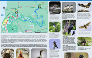 Powhatan Creek is a 23 mile tributary that flows into the James River at historic Jamestown Island. This area is recognized as one of the most environmentally significant and biodiverse natural resources on the Virginia Peninsula.
This field guide was created in partnership with the James River Association RiverRats, Virginia Master Naturalist Historic Rivers Chapter, and James City County. Many thanks to Craig Metcalfe and Judy Jones for spearheading this project.
At least 1,400 different climbers have climbed Mr. Everest … just a handful of people have paddled the entire length of the James River.
Modeled after the Appalachian Trail’s “2000-Miler” recognition program for people who hike the full trail, the Full James River Rundown consists of paddling the entire length (approximately 340 miles) of the James River from its headwaters at Iron Gate to Fort Monroe at the mouth of the Chesapeake Bay. You can travel the river straight through or do it in sections. Take as long as you need.
The rules are simple: one person (or go with a friend) on one river for the experience of a lifetime. Track your progress on our official Full Rundown chart. Full James River Rundowners receive an official certificate from the James River Association marking their achievement.
Are you ready to take the challenge?